Time has not been kind to the old drafting table, but the internet has been–because when I looked up used and new drafting tables, I found one for sale boasting of its Vyco cover. That’s the kind of cover my mother had on her big table at the oil company she worked for. So I asked the blueprint place if they carried it, and they did, and yesterday I picked up a piece of about the right size for this table. Here’s what it looked like before:
 You can see that the old maple veneer has come off in places and some edges are held together with duct tape.
Vyco is a material that feels kind of like very supple linoleum and is wonderful to work on. I could have filled in where the veneer came off, but chose not to for the usual reasons people take short-cuts–I need this working surface now. Vyco goes on with double-sticky tape; I laid out the tape (with its cover on along the edges of the table and then uncovered one end and very carefully (twice–the first time was not careful enough and had to pull all the tape and start over on that end) positioned the sheet of Vyco. With that reference end stuck down, I rolled up the sheet enough to pull the cover on the top and bottom, and then unrolled with pressure, but not quite all the way to the other end. Then pulled that tape-cover and finished.
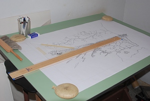
And here’s what it looks like now, with the master map and its printout on top, the new T-square, an old triangle, etc.
The round objects are map weights, leather filled with (I think) BBs or another size of shot. Map weights have the advantage of not putting any adhesive on the surface you’re working on.
Vyco is reversible (I chose green/cream) and also comes in gray/white, but I like the soft green–restful on the eyes.
Meanwhile, I’m “map cleaning” in the computer. I’ve cropped the Kings story area out of the master map and now have it in Paint Shop, removing all the marks that should not be there but could not be removed from the master before scanning (long story.) Once this would have been an even more tedious task, erasing what could be erased one by one, being careful not to raise the tooth of the paper or vellum (when my mother worked on linen, which has a sizing on it to make it smooth enough to draw on, erasing in the normal way was not an option, because it would affect the coating.) Now it’s much easier, though hand-cramping on the mouse hand.
Also easy to repair in the computer are scan errors–there was a vertical void about 4-5 pixels wide in one place. Barely visible at the size it would be printed in the book, but aesthetically unpleasant to me, and it would show in a poster-sized print. So I filled in every little gap and was glad of the white spaces without black lines.
Time to get back to it…may be able to add another picture later.
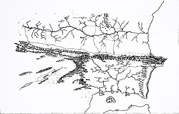
And here it is: the current state of the master map.
This is not exactly right–I printed out the master map’s present incarnation from the scan, onto 8.5 x 11 inch paper, then photographed the print–which I had to take at a slight angle with the zoom to avoid shadows from the lights, even with flash. Then cropped and resized.
The south trade road just north of the mountains degenerates in the east into a mere track and then is a road a few miles west of Bannerlíth, leading into the port city. That’s the route that Kieri took heading west from Bannerlith and finally ending up at Halveric Steading, due south from Chaya. He had gone across the closed-to-humans part of the Ladysforest to do so.
Other maps will not always agree 100% with this…as with early European maps, maps are made for different purposes and with different degrees of accuracy–and even in historical time rivers shift back and forth, volcanoes can erupt and change landscapes and trade routes, coastlines change with erosion, and so on.


Comment by Robert Conley — July 7, 2010 @ 9:12 pm
Is that Old Aare in the bottom right corner?
Comment by elizabeth — July 7, 2010 @ 9:55 pm
That’s it’s north coast, yes. Right now, very inhospitable. Big dunes down to the sea on a lot of it. Inland, bare bluffs of friable rock, and beyond that every evidence of having been dry land a long, long time.
Comment by Adam Baker — July 8, 2010 @ 6:20 am
Ah, so thats what that greed pad is called.
I didnt do a lot of hand drawn drawings in the various drafting classes that I took, but I always preferred working on tables that had those pad’s on them. I liked how the pads still let you get a good solid line because of the slight give in them, without the lines being too dark or too large.
For its age, that table really seems to be holding up very well.
Comment by Genko — July 8, 2010 @ 7:58 pm
So, you say that Kieri crossed the Ladysforest, which means the elves were aware of him and who he was at that time. They decided he wasn’t fit to be king, though, so they let him go on to Aliam’s, presumably. I wonder whether they guided him in any way or in other ways made sure he might be protected.
Comment by elizabeth — July 8, 2010 @ 8:54 pm
Not exactly. One or a few elves saw him. They knew he had some elven blood, or he could not have crossed that border, to the inner Ladysforest. But they did not know who he was at once. It had been over eight years by that time since his mother’s death; he had no coherent memories of his childhood before the abduction. Two and two were not put together right away, and not all the elves knew until much later.
Comment by FrancisT — July 9, 2010 @ 6:22 am
I want to see it bigger.
Comment by elizabeth — July 9, 2010 @ 7:26 am
When it’s ready, it will be on the Paks website and somewhat larger there. Eventually it will be available as a poster.
Comment by filkferengi — July 11, 2010 @ 12:40 pm
Woot! It looks quite lovely. I’m quite looking forward to the poster. Not that I’ve got anything like room for it–wall space for a poster has room for a bookshelf–but it’d be great for it to be available.
Comment by Gillian — July 17, 2010 @ 11:02 am
I’m a bit late commenting here, but I’m deeply intrigued to see the map picture above. It’s really interesting to see the whole map in one piece, rather than have assorted segments.
Comment by elizabeth — July 17, 2010 @ 8:39 pm
It’s going to take at least two more big sheets of map to show the whole thing, and part of it hasn’t been explored by the writer’s mind yet…so that should be interesting (and terrifying as I put lines on the map without having “been there.”)
Comment by Inge — October 6, 2010 @ 11:39 am
I was just about to ask about maps because the map in “Oath of Fealty” did not have any of the kingdom boundaries. So when Kieri is looking at Lyonya’s map and tracing its weaknesses, it’s hard to see what he was seeing. I’d also like to see how big a territory Dorrin will have to rule and where is it in Tsaia and how it relates to Pargun and Lyonya. Etc., etc. It’s not clear on the new map whether boundaries are/will be put in?
Comment by Brad R. Torgersen — October 12, 2010 @ 5:49 am
Wow, memories. I took two years of residential drafting when I was in highschool. I was probably among the last students at my school to actually use a drafting board, prior to the arrival of CAD. I remember how magical the diazo machine was — the stench of the ammonia. That was in 1990-1991. Hard to believe 20 years have passed so quickly. For some reason I can’t recall exactly, I didn’t care for the Vyco covering. Probably because I’d grown up penciling on hard-coated surfaces and the Vyco felt too “soft” as if my mechanical pencil might stab through it at any moment. But then, I always pressed too hard anyway. The 0.3 MM was almost unusable in my hands. *SNAP* (click, click, click) *SNAP*